

Introduction
Astrometry is a branch of astronomy that measures the positions and motion of celestial objects. It helps to identify exoplanets orbiting around stars, and the motion of asteroids and comets using a coordinate system.
Similar to how we calculate distances between two locations using latitudes and longitudes on earth. we create a celestial sphere of coordinates and keep the distant stars constant to measure the positions and motion of objects in space. Due to the rotation of the earth about its axis, the positions of stars in the sky appear to move from east to west.
We use a coordinate system that is unaffected by the earth's rotation by making the positions of distant stars constant. The objects close to earth appear to move faster compared to distant objects in space due to parallax error. The stars may appear to move slightly due to the revolution of the earth around the sun.
Coordinate Systems
let P be a point that is subtended at an angle θ in a 2D plane which has an x-axis and y-axis. the position vector r ̅ of a point P is denoted as x = rcosθ and y=rsinθ.

In the 3D coordinate system we have angle θ subtended between the z-axis and a point P and angle ∅ subtended between the x-axis and perpendicular of r ̅. The coordinates of point P are given by x = rcosθsin∅ , y = rsinθsin∅ and z = cos∅.
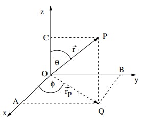
(x,y,z) are called cartesian coordinates and (r,θ,∅) are called polar coordinates. In astronomy, we use spherical polar coordinates where we use latitude δ given by δ = 90° - θ and azimuthal coordinate ∅ as longitude.
Types of Coordinate systems
1. Horizontal Coordinate System(Altitude-Azimuth)
In this coordinate system, we take the horizon as a reference plane. The position directly above the observer is called Zenith and the one below is called the nadir. The meridian (longitude) divides the earth into eastern and western hemispheres. The position of a star above the horizon is calculated by drawing a line to the horizon and drawing an angle up to the star which is called altitude. The Azimuth angle starts at 0° North and moves in clockwise till it reaches the horizon point where the star is directly above the horizon.

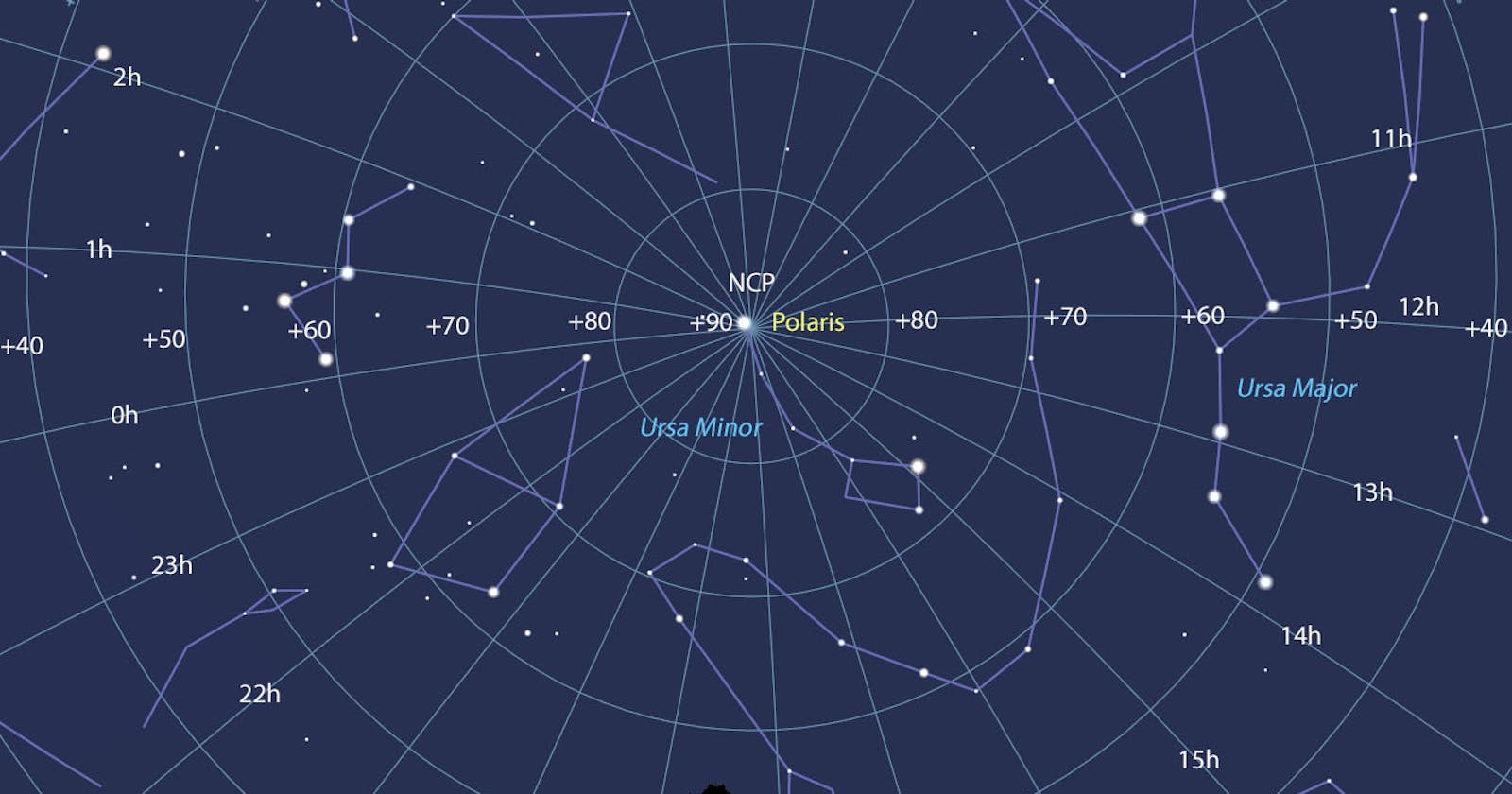
2. The Equatorial Coordinate System (Right accession and Declination)
This coordinate system is a projection of latitude and longitude onto the celestial sphere. 90° North is called the North Celestial pole and -90° South is called the south celestial pole. latitude equivalent is called declination and longitude equivalent is referred to as right accession. celestial equator represents the 24-hour clock where 1 hr = 15°. the vernal equinox is a point where the sun's revolution path crosses the celestial equator. The position of the object is measured from the vernal equinox (0 right Accession,0 Declination) to the right and declination which is altitude measured from the celestial equator either north or south.
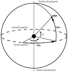
Image Courtesy:link
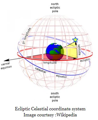
3. The Ecliptic Coordinate system
In this coordinate system, the orbital plane of the earth moving around the sun is taken as a reference plane for latitude which is known as Ecliptic. The point where the orbital plane and equatorial plane intersect is directed toward the vernal equinox. The longitude is measured from the vernal equinox with angle ranges from 0° to 360°. The latitude of the object is measured either North or South of the ecliptic.
4. Galactic Coordinate System
The coordinate system is centered on the sun and is directed toward the center of the milky way. Milkyway forms the galactic plane. The galactic longitude is measured from the center of the milky way which starts from 0° to 360° counterclockwise. The galactic latitude of the object is measured either North or South of the galactic plane.

Image courtesy: link
5. Supergalactic Coordinate System
In this coordinate system, the supergalactic cluster is taken as a reference plane. Supergalactic longitude (SGL) starts from 0° at the intersection point of the galactic and supergalactic cluster planes. the supergalactic plane is used as a reference for defining Supergalactic latitude (SGB). The supergalactic plane is approximately perpendicular to the plane of milk way at an angle is 84.5°. This coordinate system is used to detect distant galaxies and superclusters.
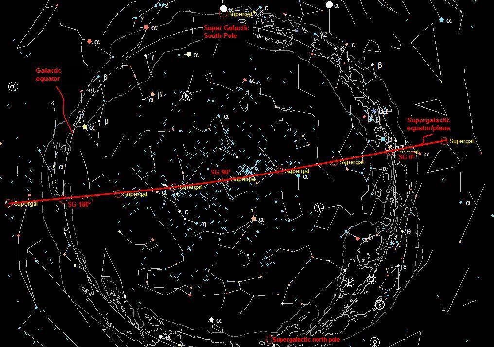
Image courtesy:link
Doppler Effect
In Astronomy, the doppler effect is defined as the change in the frequency or wavelength of light coming from a source due to relative motion towards or away from the observer. This effect is used to measure the radial velocities of objects in space.
Redshift: when the light source moves away from the observer the wavelength increases and frequency decreases and spectral lines appears to be redshifted from the reference line in the visible spectrum.
Blueshift: when the light source moves towards the observer the wavelength decreases and frequency increases and spectral lines appears to be blueshifted from the reference line in the visible spectrum.

Radial Velocity Method
Radial velocity is measured by using the redshift or blueshift of the star or galaxy spectrum. It is a widely used method in astronomy for detecting exoplanets. this method is also known as Doppler Spectroscopy.
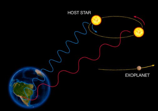
Image courtesy:link
Transit Method
This method is applied to a star-planet system to detect the exoplanets. the brightness of light coming from the star is slightly blocked when the planet transit as observed from earth. During transit, we can observe a dip in the brightness of the light. This method is used to measure the size and density of the planet.
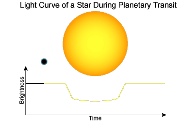
Image Courtesy:link
This method is only applicable for planets' transit in horizontal elliptical orbits but not in vertical elliptical orbits because a planet never transits in vertical orbits observed from earth.
In conclusion, astrometry methods are useful for detecting the position and motions of stars and exoplanets within the plane of the sky.